|
search place name
|
||
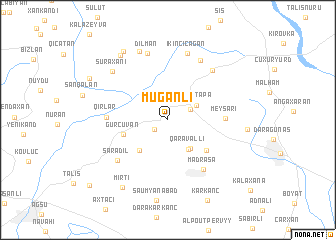
Muğanlı (Şamaxı, Azerbaijan)Muğanlı is a town in the Şamaxı region of Azerbaijan. An overview map of the region around Muğanlı is displayed below.
regional and 3d topo map of Muğanlı, Azerbaijan ::
Muğanlı airports ::
The nearest airport is BAK - Baku Heydar Aliyev, located 130.4 km east of Muğanlı.
Nearby towns ::
Xoylu (1.5km south west) //
Dimitrovka (2.3km north east) //
Qurdtǝpǝ (2.9km north east) //
Qaravǝlli (3.7km south east) //
Mirikǝnd (3.7km south east) //
Saqiyan (4.2km south west) //
Gürcüvǝn (4.1km south west) //
Mǝlcǝk (4.7km south east) //
Meysǝri (4.9km east) //
Mǝdrǝsǝ (6.3km south east) //
Qırlar (5.2km west) //
Şǝrǝdil (6.3km south west) //
Dǝdǝgünǝş (6.7km north east) //
Birinci Çağan (7.1km north) //
Dilman (7.6km north) //
İkinci Çağan (7.7km north) //
Suraxanı (7.2km north west) //
Hacıman (8.1km north) //
Kalva (8.2km north west) //
Bash-Khynysly (6.8km east) //
Mırtı (8.5km south west) //
Xatman (8.6km north west) //
Pirqaraçuxa (8.1km north west) //
Kadzhar (9.9km south west) //
[all distances 'as the bird flies' and approximate]  Places with similar names to Muğanlı, Azerbaijan ::
Disclaimer :: Information on this page comes without warranty of any kind |
||
|
Where is Muğanlı? Elevation and coordinates ::
Latitude (lat): 40°39'51"N Longitude (lon): 48°31'42"E
Elevation (approx.): 831m (map arrows pan, magnifying glasses zoom) |
||
|
Visiting Muğanlı? Hotel/Accommodation ::
Book a hotel in Muğanlı Travel Guide ::
Buy a travel guide for Azerbaijan rental cars ::
car rental offers GPS waypoint ::
download a GPX waypoint (PoI) of Muğanlı for your GPS receiver
|
||