|
search place name
|
||
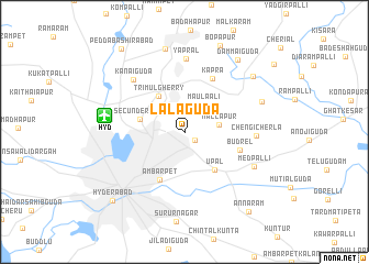
Lālāguda (Andhra Pradesh, India)Lālāguda is a town in the Andhra Pradesh region of India. An overview map of the region around Lālāguda is displayed below.
regional and 3d topo map of Lālāguda, India ::
Lālāguda airports ::
The nearest airport is HYD - Hyderabad, located 7.9 km west of Lālāguda.
Nearby towns ::
Nasāram (1.3km south east) //
Maula Ali (3.4km north east) //
Mallāpur (3.4km east) //
Trimulgherry (4.4km north west) //
Secunderābād (4.5km west) //
Upal (4.8km south east) //
Ambarpet (5.4km south west) //
Budrel (5.6km east) //
Kāpra (6.0km north east) //
Chengi Cherla (6.9km east) //
Kanaiguda (7.2km north west) //
Yaprāl (7.5km north) //
Medpalli (7.7km south east) //
Charlapalli (8.2km east) //
Bolārum (8.7km north) //
Nāgāvaram (8.7km north east) //
Dammaiguda (9.0km north east) //
Bopāpur (9.4km north) //
Hyderābād (9.9km south west) //
Annāram (10.2km south east) //
Pedda Bashīrābād (10.4km north west) //
[all distances 'as the bird flies' and approximate]  Places with similar names to Lālāguda, India ::
// La Algaida (ES)
// La Algoda (ES)
// Loolo Ekoto (CD)
// Lālgudi (IN)
// Lelkada (LK)
// Lellagoda (LK)
// Lolgoda (LK)
// Loolkade (LK)
// Lāleh Kotī (IR)
// Lel Gat (PK)
Disclaimer :: Information on this page comes without warranty of any kind |
||
|
Where is Lālāguda? Elevation and coordinates ::
Latitude (lat): 17°26'17"N Longitude (lon): 78°32'26"E
Elevation (approx.): 523m (map arrows pan, magnifying glasses zoom) |
||
|
Visiting Lālāguda? Hotel/Accommodation ::
Book a hotel in Lālāguda Travel Guide ::
Buy a travel guide for India rental cars ::
car rental offers GPS waypoint ::
download a GPX waypoint (PoI) of Lālāguda for your GPS receiver
|
||