|
search place name
|
||
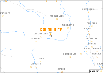
Palo Dulce (Sinaloa, Mexico)Palo Dulce is a town in the Sinaloa region of Mexico. An overview map of the region around Palo Dulce is displayed below.
regional and 3d topo map of Palo Dulce, Mexico ::
Palo Dulce airports ::
The nearest airport is CUL - Culiacan Intl, located 77.8 km north west of Palo Dulce.
Other airports nearby include MZT - Mazatlan General Rafael Buelna Intl (142.6 km south east), Nearby towns ::
La Cuchilla (2.5km north east) //
Los Caballos (3.4km west) //
El Tapón (5.4km west) //
Palos Dulces (6.7km north) //
Buenavista (6.4km north east) //
Campanillas (9.8km south east) //
[all distances 'as the bird flies' and approximate] 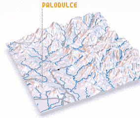 Places with similar names to Palo Dulce, Mexico ::
// Paletillas (EC)
// Palo Dulce (MX)
// Palo Dulce (MX)
// Palo Dulce (MX)
// Palo Dulce (MX)
// Palo Dulce (MX)
// Palo Dulce (MX)
// Paletales (HN)
// Paletillas (PE)
// Platillos (PE)
Disclaimer :: Information on this page comes without warranty of any kind |
||
|
Where is Palo Dulce? Elevation and coordinates ::
Latitude (lat): 24°19'0"N Longitude (lon): 106°53'0"W
Elevation (approx.): 513m (map arrows pan, magnifying glasses zoom) |
||
|
Visiting Palo Dulce? Hotel/Accommodation ::
Book a hotel in Palo Dulce Travel Guide ::
Buy a travel guide for Mexico rental cars ::
car rental offers GPS waypoint ::
download a GPX waypoint (PoI) of Palo Dulce for your GPS receiver
|
||