|
search place name
|
||
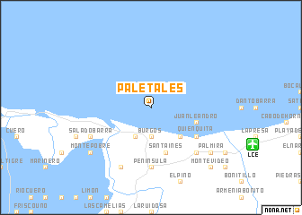
Paletales (Colón, Honduras)Paletales is a town in the Colón region of Honduras. An overview map of the region around Paletales is displayed below.
regional and 3d topo map of Paletales, Honduras ::
Paletales airports ::
The nearest airport is LCE - La Ceiba Goloson Intl, located 13.0 km east of Paletales.
Other airports nearby include TEA - Tela (54.6 km west), RTB - Roatan Juan Manuel Galvez Intl (75.8 km north east), SAP - San Pedro Sula La Mesa Intl (108.9 km west), GJA - Guanaja (135.0 km north east), Nearby towns ::
Masicales (1.9km north) //
Burgos (3.7km south) //
Zacate (4.1km south west) //
El Porvenir (5.1km south east) //
Juan Leandro (5.7km east) //
Santa Inés (5.8km south) //
Orotina (5.8km south) //
Victoria (5.8km south) //
Pantera (5.8km south) //
Quienquita (6.5km south east) //
Coco Pando (6.5km south east) //
Península (7.4km south) //
Pozo Zarco (7.7km south east) //
Montecristo (7.7km south east) //
Salado Barra (8.0km south west) //
La Unión (8.2km south west) //
Monte Pobre (9.0km south west) //
Palmira (9.0km south east) //
Montevideo (10.3km south east) //
[all distances 'as the bird flies' and approximate]  Places with similar names to Paletales, Honduras ::
// Paletillas (EC)
// Palo Dulce (MX)
// Palo Dulce (MX)
// Palo Dulce (MX)
// Palo Dulce (MX)
// Palo Dulce (MX)
// Palo Dulce (MX)
// Palo Dulce (MX)
// Paletillas (PE)
// Platillos (PE)
Disclaimer :: Information on this page comes without warranty of any kind |
||
|
Where is Paletales? Elevation and coordinates ::
Latitude (lat): 15°47'0"N Longitude (lon): 86°58'0"W
Elevation (approx.): -32768m (map arrows pan, magnifying glasses zoom) |
||
|
Visiting Paletales? Hotel/Accommodation ::
Book a hotel in Paletales Travel Guide ::
Buy a travel guide for Honduras rental cars ::
car rental offers GPS waypoint ::
download a GPX waypoint (PoI) of Paletales for your GPS receiver
|
||