|
search place name
|
||
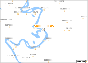
San Nicolás (Tabasco, Mexico)San Nicolás is a town in the Tabasco region of Mexico. An overview map of the region around San Nicolás is displayed below.
regional and 3d topo map of San Nicolás, Mexico ::
San Nicolás airports ::
The nearest airport is CME - Ciudad Del Carmen Intl, located 123.6 km north of San Nicolás.
Other airports nearby include VSA - Villahermosa C P A Carlos Rovirosa Intl (159.5 km west), TGZ - Tuxtla Gutierrez Angel Albino Corzo (211.7 km south west), Nearby towns ::
El Bilín (2.0km north west) //
Canitzán (3.7km south) //
Chusmuk (4.1km south east) //
Las Tablas (4.2km west) //
Multé (8.2km north west) //
Estapilla (8.2km south west) //
Agua Fría (8.4km east) //
Las Campanas (10.2km north west) //
Buenavista (12.2km north east) //
[all distances 'as the bird flies' and approximate]  Places with similar names to San Nicolás, Mexico ::
// Zünqülǝş (AZ)
// Singlis (DE)
// Cengles (IT)
// San Nicolas (IT)
// San Nicolás (CU)
// San Nicolás (CU)
// San Nicolás (CU)
// San Nicolás (CU)
// San Nicolás (CU)
// San Nicolás (CU)
Disclaimer :: Information on this page comes without warranty of any kind |
||
|
Where is San Nicolás? Elevation and coordinates ::
Latitude (lat): 17°37'0"N Longitude (lon): 91°22'0"W
Elevation (approx.): 10m (map arrows pan, magnifying glasses zoom) |
||
|
Visiting San Nicolás? Hotel/Accommodation ::
Book a hotel in San Nicolás Travel Guide ::
Buy a travel guide for Mexico rental cars ::
car rental offers GPS waypoint ::
download a GPX waypoint (PoI) of San Nicolás for your GPS receiver
|
||