|
search place name
|
||
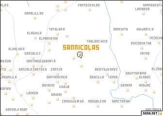
San Nicolás (Hidalgo, Mexico)San Nicolás is a town in the Hidalgo region of Mexico. An overview map of the region around San Nicolás is displayed below.
regional and 3d topo map of San Nicolás, Mexico ::
San Nicolás airports ::
The nearest airport is PCA - Pachuca Ingeniero Juan Guillermo Villasana, located 37.2 km south of San Nicolás.
Other airports nearby include MEX - Mexico City Licenciado Benito Juarez Intl (108.5 km south), TXA - Tlaxcala (120.9 km south east), TLC - Toluca Licenciado Adolfo Lopez Mateos Intl (137.7 km south west), QRO - Queretaro Intercontinental (138.0 km west), Nearby towns ::
Plomosas (1.9km south) //
Mecas (1.7km west) //
Zapote (2.5km north east) //
Tablón Chico (4.4km north east) //
El Encino (6.0km north west) //
Contzá (6.4km south west) //
Saucillo (6.6km south east) //
Benito Juárez (6.6km south east) //
El Sitio (6.8km south west) //
Santhé (7.2km west) //
Hermosillo (7.2km west) //
Santa Mónica (7.6km south west) //
Totolapa (7.6km north west) //
El Porvenir (7.7km north west) //
Xidejé (8.5km south west) //
Tensa (8.9km south east) //
Boxaxni (10.2km south west) //
[all distances 'as the bird flies' and approximate] 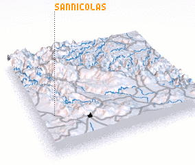 Places with similar names to San Nicolás, Mexico ::
// Zünqülǝş (AZ)
// Singlis (DE)
// Cengles (IT)
// San Nicolas (IT)
// San Nicolás (CU)
// San Nicolás (CU)
// San Nicolás (CU)
// San Nicolás (CU)
// San Nicolás (CU)
// San Nicolás (CU)
Disclaimer :: Information on this page comes without warranty of any kind |
||
|
Where is San Nicolás? Elevation and coordinates ::
Latitude (lat): 20°24'0"N Longitude (lon): 98°53'0"W
Elevation (approx.): 2007m (map arrows pan, magnifying glasses zoom) |
||
|
Visiting San Nicolás? Hotel/Accommodation ::
Book a hotel in San Nicolás Travel Guide ::
Buy a travel guide for Mexico rental cars ::
car rental offers GPS waypoint ::
download a GPX waypoint (PoI) of San Nicolás for your GPS receiver
|
||