|
search place name
|
||
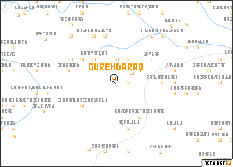
Gūreh Daraq (Ostān-e Āz̄arbāyjān-e Sharqī, Iran)Gūreh Daraq is a town in the Ostān-e Āz̄arbāyjān-e Sharqī region of Iran. An overview map of the region around Gūreh Daraq is displayed below.
regional and 3d topo map of Gūreh Daraq, Iran ::
Gūreh Daraq airports ::
The nearest airport is TBZ - Tabriz Intl, located 58.7 km south west of Gūreh Daraq.
Nearby towns ::
Dāmanābād (1.5km east) //
Qezeljeh (2.5km north east) //
Golūjeh-ye Mollā Lār (3.9km north) //
Moḩammad Reẕā Kandī (4.2km north) //
Mollālār-e Moḩammnadreẕā Kandī (4.2km north) //
Sārī Yārqān (4.8km north west) //
Chūpānlār-e Sardārlū (5.6km south west) //
Gūy Daraq-e Tāzeh Kand (6.1km south east) //
Naşīrābād (5.8km north west) //
Dāylār (5.9km north east) //
Zanjīr Bolāgh (5.9km east) //
Āqā ‘Alīlū (7.4km south) //
Holān (7.7km north) //
Daghalīān-e Pāʼīn (7.7km north) //
Zangābād (6.4km west) //
Āgh Darag (7.0km north west) //
Daghlīān-e ‘Olyā (8.1km north) //
Chelān (8.8km north east) //
‘Alīābād (9.5km north west) //
Tāzeh Kand-e Chelān (9.6km north east) //
[all distances 'as the bird flies' and approximate]  Places with similar names to Gūreh Daraq, Iran ::
// Karadirek (TR)
// Karadoruk (TR)
// Karadoruk (TR)
// Kurudereköy (TR)
// Kara-Terek (RU)
// Carderock (US)
// Courtrock (US)
// Curi Tarqui (EC)
// Karaterek (KZ)
// Kara-Turuk (KZ)
Disclaimer :: Information on this page comes without warranty of any kind |
||
|
Where is Gūreh Daraq? Elevation and coordinates ::
Latitude (lat): 38°23'54"N Longitude (lon): 46°48'58"E
Elevation (approx.): 1860m (map arrows pan, magnifying glasses zoom) |
||
|
Visiting Gūreh Daraq? Hotel/Accommodation ::
Book a hotel in Gūreh Daraq Travel Guide ::
Buy a travel guide for Iran rental cars ::
car rental offers GPS waypoint ::
download a GPX waypoint (PoI) of Gūreh Daraq for your GPS receiver
|
||