|
search place name
|
||
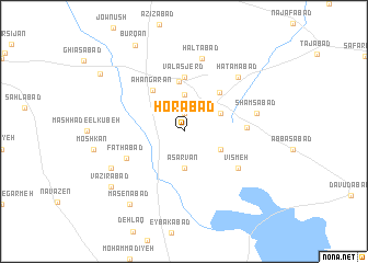
Ḩorābād (Iran)Ḩorābād is a town in Iran. An overview map of the region around Ḩorābād is displayed below.
regional and 3d topo map of Ḩorābād, Iran ::
Ḩorābād airports ::
The nearest airport is THR - Teheran Mehrabad Intl, located 209.2 km north east of Ḩorābād.
Nearby towns ::
Khalajābād (1.9km north) //
Sharafābād (3.7km north) //
Āsarvān (3.7km south) //
Moşleḩābād (3.7km north east) //
Kamālābād-e Soflá (3.6km south east) //
Kamālābād-e ‘Olyā (3.6km north east) //
Nez̧āmābād (5.1km north) //
Āhangarān (5.0km north west) //
Velāshjerd (5.0km north east) //
Ḩoseynābād (5.6km north) //
Valāsjerd (5.6km north) //
Fatḩābād (5.5km south west) //
Khvoshdūn (5.3km east) //
Vīsmeh (5.9km south east) //
Ḩaltābād (7.6km north) //
Shamsābād (6.4km east) //
Ḩātamābād (7.2km north east) //
Mīchān (7.2km south west) //
Masenābād (8.7km south west) //
Vazīrābād (8.4km south west) //
Būrqān (9.7km north west) //
Dowlatābād (9.2km north west) //
[all distances 'as the bird flies' and approximate]  Places with similar names to Ḩorābād, Iran ::
Disclaimer :: Information on this page comes without warranty of any kind |
||
|
Where is Ḩorābād? Elevation and coordinates ::
Latitude (lat): 34°21'0"N Longitude (lon): 49°42'0"E
Elevation (approx.): 1689m (map arrows pan, magnifying glasses zoom) |
||
|
Visiting Ḩorābād? Hotel/Accommodation ::
Book a hotel in Ḩorābād Travel Guide ::
Buy a travel guide for Iran rental cars ::
car rental offers GPS waypoint ::
download a GPX waypoint (PoI) of Ḩorābād for your GPS receiver
|
||