|
search place name
|
||
Bugaragara (Kigali, Rwanda)Bugaragara is a town in the Kigali region of Rwanda. An overview map of the region around Bugaragara is displayed below.
regional and 3d topo map of Bugaragara, Rwanda ::

Bugaragara airports ::
The nearest airport is KGL - Kigali Intl, located 20.1 km east of Bugaragara.
Other airports nearby include GYI - Gisenyi (83.1 km west), GOM - Goma (85.5 km west), KME - Kamembe (132.3 km south west), BKY - Bukavu/kavumu Bukavu Kavumu (135.9 km west), Nearby towns ::
Rutonde (1.9km north) //
Rimwe (4.1km north west) //
Rutondwe (5.9km north) //
Runda (6.1km south) //
Nyamweru (6.7km south east) //
Gitsuba (6.7km north west) //
Shyorongi (6.9km north) //
Jari (7.9km north east) //
Taba (8.2km south west) //
Rwani (8.3km north west) //
Muvumu (9.3km north west) //
Kigali (9.5km south east) //
Rutongo (10.0km north east) //
[all distances 'as the bird flies' and approximate] 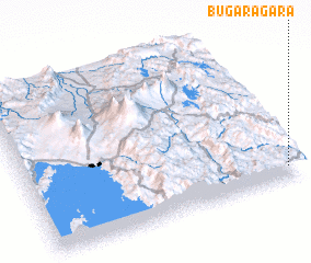 Places with similar names to Bugaragara, Rwanda ::
// Bakragara (IQ)
// Böğrüeğri (TR)
// Bāqargarh (IN)
// Boukari Koyré (NE)
// Bakorokoro (GN)
// Bagargar (NG)
// Bakarkura (NG)
// Bakroukro (CI)
Disclaimer :: Information on this page comes without warranty of any kind |
||
|
Where is Bugaragara? Elevation and coordinates ::
Latitude (lat): 1°55'0"S Longitude (lon): 29°58'0"E
Elevation (approx.): 1496m (map arrows pan, magnifying glasses zoom) |
||
|
Visiting Bugaragara? Hotel/Accommodation ::
Book a hotel in Bugaragara Travel Guide ::
Buy a travel guide for Rwanda rental cars ::
car rental offers GPS waypoint ::
download a GPX waypoint (PoI) of Bugaragara for your GPS receiver
|
||