|
search place name
|
||
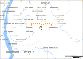
Ban Nakhanay (Laos)Ban Nakhanay is a town in Laos. An overview map of the region around Ban Nakhanay is displayed below.
regional and 3d topo map of Ban Nakhanay, Laos ::
Ban Nakhanay airports ::
The nearest airport is ZVK - Savannakhet, located 45.5 km south of Ban Nakhanay.
Other airports nearby include SNO - Sakon Nakhon (85.8 km west), PKZ - Pakse (222.9 km south east), Nearby towns ::
Ban Gnangkham (1.9km north) //
Ban Dôngphao (2.6km north west) //
Ban Nasop (2.6km north east) //
Ban Nao Tai (3.7km north) //
Ban Nao Nua (4.1km north east) //
Ban Laofay (5.3km east) //
Ban Nang (5.3km west) //
Ban Dôngphou (5.6km north) //
Ban Xa Du (5.6km west) //
Ban Na Vang (5.6km west) //
Ban Somsaat (6.5km north west) //
Ban Houayhè (6.5km north west) //
Ban Dông Gnay (7.6km north) //
Ban Phakphua (8.0km north west) //
Ban Dôngphakphua (8.0km north west) //
Ban Nônnadèng (2) (8.0km north east) //
Ban Nônnadèng (1) (9.0km north east) //
[all distances 'as the bird flies' and approximate]  Places with similar names to Ban Nakhanay, Laos ::
Disclaimer :: Information on this page comes without warranty of any kind |
||
|
Where is Ban Nakhanay? Elevation and coordinates ::
Latitude (lat): 16°57'0"N Longitude (lon): 104°53'0"E
Elevation (approx.): 157m (map arrows pan, magnifying glasses zoom) |
||
|
Visiting Ban Nakhanay? Hotel/Accommodation ::
Book a hotel in Ban Nakhanay Travel Guide ::
Buy a travel guide for Laos rental cars ::
car rental offers GPS waypoint ::
download a GPX waypoint (PoI) of Ban Nakhanay for your GPS receiver
|
||