|
search place name
|
||
Kombobari (Papua New Guinea)Kombobari is a town in Papua New Guinea. An overview map of the region around Kombobari is displayed below.
regional and 3d topo map of Kombobari, Papua New Guinea ::

Kombobari airports ::
The nearest airport is GKA - Goroka, located 25.8 km south of Kombobari.
Other airports nearby include MAG - Madang (85.1 km north east), HGU - Mount Hagen (118.6 km west), LAE - Nadzab (170.2 km south east), Nearby towns ::
Kempeni (3.7km east) //
Yomika (4.1km north east) //
Tomo (7.4km north) //
Yarieka (7.6km east) //
Kempenkobia (7.6km east) //
Asariyufa Number 3 (8.3km south west) //
Tauya (9.2km north east) //
[all distances 'as the bird flies' and approximate] 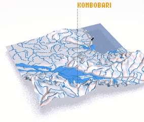 Places with similar names to Kombobari, Papua New Guinea ::
// Camíbar (CR)
// Camíbar (CR)
// Kiamabara (KE)
// Comibar (MX)
// Koma Béri (NE)
// Gambi Bera (PK)
// Cumbibirá (PE)
// Kamabara (RW)
// Kamabu-ri (KP)
// Kawm Abū Rayyah (EG)
Disclaimer :: Information on this page comes without warranty of any kind |
||
|
Where is Kombobari? Elevation and coordinates ::
Latitude (lat): 5°51'0"S Longitude (lon): 145°22'0"E
Elevation (approx.): 998m (map arrows pan, magnifying glasses zoom) |
||
|
Visiting Kombobari? Hotel/Accommodation ::
Book a hotel in Kombobari Travel Guide ::
rental cars ::
car rental offers GPS waypoint ::
download a GPX waypoint (PoI) of Kombobari for your GPS receiver
|
||