|
search place name
|
||
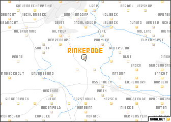
Rinkerode (Nordrhein-Westfalen, Germany)Rinkerode is a town in the Nordrhein-Westfalen region of Germany. An overview map of the region around Rinkerode is displayed below.
regional and 3d topo map of Rinkerode, Germany ::
Rinkerode airports ::
The nearest airport is FMO - Muenster/osnabrueck Munster Osnabruck, located 31.7 km north of Rinkerode.
Other airports nearby include DTM - Dortmund (37.2 km south), ZCA - Arnsberg Menden (43.4 km south), GUT - Guetersloh Gutersloh (43.7 km east), PAD - Paderborn Lippstadt (69.6 km east), Nearby towns ::
Altendorf (2.2km south west) //
Hemmer (2.2km north west) //
Eickenbeck (2.2km south east) //
Sungern (2.2km north east) //
Storp (2.2km north east) //
Rummler (4.4km north east) //
Ahrenhorst (3.4km east) //
Herrenburg (5.1km north west) //
Bach (6.0km north) //
Berl (6.0km north) //
Ossenbeck (6.0km south) //
Angelmodde (7.4km north) //
Albersloh (4.9km east) //
Hiltrup (6.5km north west) //
Natorp (5.9km south east) //
Rieth (7.8km south) //
Welbeck (8.2km north east) //
Geist (8.2km north west) //
Drensteinfurt (7.2km south east) //
Hegemer (8.7km south west) //
Ascheberg (8.7km south west) //
[all distances 'as the bird flies' and approximate]  Places with similar names to Rinkerode, Germany ::
// Ríonegrito (ES)
// Raincourt (FR)
// Renaucourt (FR)
// Riencourt (FR)
// Roncourt (FR)
// Rancourt (FR)
// Rancourt (FR)
// Rengård (SE)
// Rainecourt (FR)
// Roncourt (FR)
Disclaimer :: Information on this page comes without warranty of any kind |
||
|
Where is Rinkerode? Elevation and coordinates ::
Latitude (lat): 51°51'0"N Longitude (lon): 7°41'0"E
Elevation (approx.): 57m (map arrows pan, magnifying glasses zoom) |
||
|
Visiting Rinkerode? Hotel/Accommodation ::
Book a hotel in Rinkerode Travel Guide ::
Buy a travel guide for Germany rental cars ::
car rental offers GPS waypoint ::
download a GPX waypoint (PoI) of Rinkerode for your GPS receiver
|
||