|
search place name
|
||
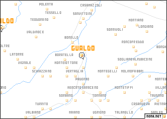
Gualdo (Italy)Gualdo is a town in Italy. An overview map of the region around Gualdo is displayed below.
regional and 3d topo map of Gualdo, Italy ::
Gualdo airports ::
The nearest airport is FRL - Forli, located 22.4 km north west of Gualdo.
Other airports nearby include RMI - Rimini (33.0 km east), FLR - Firenze (83.1 km west), BLQ - Bologna (92.8 km north west), PEG - Perugia (105.4 km south), Nearby towns ::
Bareto (1.9km south) //
Ca di Guido (1.9km south) //
Monte Iottone (3.2km south west) //
Vertaglia (3.9km south) //
Boratella (3.0km west) //
Borello (4.3km north west) //
Falconara (4.6km south west) //
Mastro (4.6km south west) //
Paderno (5.6km south) //
Montegelli (5.5km south east) //
Mercato Saraceno (7.4km south) //
Strigara (5.6km east) //
Montecastello (7.9km south) //
Rontagnano (7.9km south) //
Ciola (6.5km south west) //
San Carlo (8.3km north) //
Sorrivoli (7.6km north east) //
[all distances 'as the bird flies' and approximate]  Places with similar names to Gualdo, Italy ::
Disclaimer :: Information on this page comes without warranty of any kind |
||
|
Where is Gualdo? Elevation and coordinates ::
Latitude (lat): 44°1'0"N Longitude (lon): 12°12'0"E
Elevation (approx.): 82m (map arrows pan, magnifying glasses zoom) |
||
|
Visiting Gualdo? Hotel/Accommodation ::
Book a hotel in Gualdo Travel Guide ::
Buy a travel guide for Italy rental cars ::
car rental offers GPS waypoint ::
download a GPX waypoint (PoI) of Gualdo for your GPS receiver
|
||