|
search place name
|
||
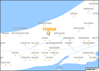
Tranum (Nordjylland, Denmark)Tranum is a town in the Nordjylland region of Denmark. An overview map of the region around Tranum is displayed below.
regional and 3d topo map of Tranum, Denmark ::
Tranum airports ::
The nearest airport is AAL - Aalborg, located 23.6 km east of Tranum.
Other airports nearby include TED - Thisted (46.7 km west), KRP - Karup (95.4 km south), AAR - Aarhus (116.6 km south east), STA - Stauning (144.5 km south west), Nearby towns ::
Jarmsted (1.9km south) //
Janum (2.1km south west) //
Bratbjerg (2.0km east) //
Øster Svenstrup (3.8km south) //
Tranum Strand (3.8km north) //
Årup (5.6km south) //
Skovsgård (5.7km south) //
Telling (4.8km south west) //
Torslev (7.5km south) //
Fredensdal (4.4km south east) //
Flegum (7.5km south) //
Brovst (5.5km south east) //
Lørsted (8.0km south) //
[all distances 'as the bird flies' and approximate] 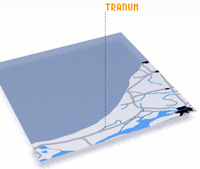 Places with similar names to Tranum, Denmark ::
// Tarinam (MM)
// Dornum (DE)
// Teranum (MY)
// Tornimäe (EE)
// Darnīām (IR)
// Turinuma (EC)
// Tarua-anim (ID)
// Tarnamo (GH)
// Darou Naïm (SN)
// Darou Nem (SN)
Disclaimer :: Information on this page comes without warranty of any kind |
||
|
Where is Tranum? Elevation and coordinates ::
Latitude (lat): 57°8'0"N Longitude (lon): 9°28'0"E
Elevation (approx.): 16m (map arrows pan, magnifying glasses zoom) |
||
|
Visiting Tranum? Hotel/Accommodation ::
Book a hotel in Tranum Travel Guide ::
Buy a travel guide for Denmark rental cars ::
car rental offers GPS waypoint ::
download a GPX waypoint (PoI) of Tranum for your GPS receiver
|
||