|
search place name
|
||
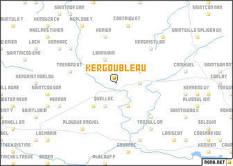
Kergoubleau (Bretagne, France)Kergoubleau is a town in the Bretagne region of France. An overview map of the region around Kergoubleau is displayed below.
regional and 3d topo map of Kergoubleau, France ::
Kergoubleau airports ::
The nearest airport is SBK - St.-brieuc Armor Armor, located 35.5 km north east of Kergoubleau.
Other airports nearby include LAI - Lannion (52.6 km north), MXN - Morlaix Ploujean (55.6 km north west), LRT - Lorient Lann Bihoue (64.4 km south), VNE - Vannes Meucon (75.1 km south east), Nearby towns ::
Saint-Nicolas-du-Pélem (2.5km east) //
Bothoa (3.1km north east) //
Lanrivain (3.9km north) //
Nothéret (3.9km south) //
Quellec (3.9km south) //
Plounevez-Quintin (4.5km south west) //
Kérien (7.5km north) //
Trémargat (5.3km west) //
Sainte-Tréphine (6.7km south east) //
Kergrist-Lan (6.7km north east) //
Plouguernével (8.3km south west) //
Trozullon (8.3km south east) //
Peumerit-Quintin (7.4km north west) //
Kerpert (8.9km north east) //
[all distances 'as the bird flies' and approximate]  Places with similar names to Kergoubleau, France ::
// Krakebüll (DE)
// Guaracabulla (CU)
// Çarıkballı (TR)
// Kurucabel (TR)
// Carcabal (ES)
// Gargaboulli (BF)
// Korkobièl (BF)
// Koragbal (IN)
// Corre Caballo (MX)
// Garūk-e Bālā (IR)
Disclaimer :: Information on this page comes without warranty of any kind |
||
|
Where is Kergoubleau? Elevation and coordinates ::
Latitude (lat): 48°19'0"N Longitude (lon): 3°12'0"W
Elevation (approx.): 218m (map arrows pan, magnifying glasses zoom) |
||
|
Visiting Kergoubleau? Hotel/Accommodation ::
Book a hotel in Kergoubleau Travel Guide ::
Buy a travel guide for France rental cars ::
car rental offers GPS waypoint ::
download a GPX waypoint (PoI) of Kergoubleau for your GPS receiver
|
||