|
search place name
|
||
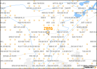
Zand (Limburg, Belgium)Zand is a town in the Limburg region of Belgium. An overview map of the region around Zand is displayed below.
regional and 3d topo map of Zand, Belgium ::
Zand airports ::
The nearest airport is MST - Maastricht, located 19.1 km south of Zand.
Other airports nearby include GKE - Geilenkirchen (23.7 km south east), EIN - Eindhoven (49.1 km north west), MGL - Moenchengladbach Monchengladbach (54.1 km east), LGG - Liege (54.6 km south west), Nearby towns ::
Kraaienboshof (0.0km north) //
Elen (1.9km south) //
Meerheuvel (1.9km south) //
Oude Hei (1.2km west) //
Wurfeld (1.9km north) //
Nuchelenhof (2.2km south east) //
Moors Kamp (2.2km north east) //
Kokkelert (2.3km east) //
Heppenert (2.3km east) //
Biegter Weerd (3.7km south) //
Papenhoven (3.7km south) //
Schootsheide (2.3km west) //
De Staart (2.3km west) //
Ven (3.7km north) //
Visserweert (3.0km south east) //
Elerweert (3.0km south east) //
Maaseik (3.0km north east) //
Alden Eik (3.0km north east) //
Visakker (3.9km south) //
De Broeken (3.0km south west) //
Leu (3.9km north) //
Gremelslo (3.9km north) //
Broekberg (3.9km north) //
Schippersbeek (4.4km south east) //
Graskamp (4.4km south west) //
Rotem (4.4km south west) //
Ophoven (4.4km north east) //
Negenoord (5.6km south) //
Roosteren (3.5km east) //
[all distances 'as the bird flies' and approximate]  Places with similar names to Zand, Belgium ::
Disclaimer :: Information on this page comes without warranty of any kind |
||
|
Where is Zand? Elevation and coordinates ::
Latitude (lat): 51°5'0"N Longitude (lon): 5°46'0"E
Elevation (approx.): 30m (map arrows pan, magnifying glasses zoom) |
||
|
Visiting Zand? Hotel/Accommodation ::
Book a hotel in Zand Travel Guide ::
Buy a travel guide for Belgium rental cars ::
car rental offers GPS waypoint ::
download a GPX waypoint (PoI) of Zand for your GPS receiver
|
||