|
search place name
|
||
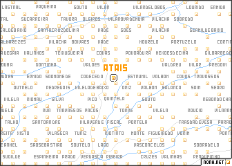
Atãis (Braga, Portugal)Atãis is a town in the Braga region of Portugal. An overview map of the region around Atãis is displayed below.
regional and 3d topo map of Atãis, Portugal ::
Atãis airports ::
The nearest airport is OPO - Porto, located 57.1 km south west of Atãis.
Other airports nearby include VGO - Vigo (60.2 km north), VRL - Vila Real (75.1 km south east), SCQ - Santiago (131.0 km north), BGC - Braganca (141.6 km east), Nearby towns ::
Barros (0.0km north) //
Sande (1.9km south) //
Cisão (1.4km west) //
Gomide (1.4km east) //
Portela de Vade (1.4km west) //
Pico (2.3km south west) //
Oriz (2.3km south east) //
Santa Luzia (2.3km south west) //
Codeceda (2.8km west) //
Estrumil (2.8km east) //
Fonte Mulhe (3.7km north) //
Quintela (3.7km south) //
Coucieiro (3.7km south) //
Valões (3.3km north west) //
Penascais (3.3km north west) //
Vilela de Baixo (3.3km south west) //
Prado (3.3km south west) //
Oriz (3.3km south east) //
Rego (3.3km south east) //
Quintãs (4.0km north) //
Covas (4.0km north) //
Martinga (4.0km north) //
Aboim da Nóbrega (4.0km north) //
Ponte (4.0km south) //
Grovelas (4.6km north west) //
Permedelos (4.6km north west) //
Póvoa Dura (4.6km north east) //
Gondomar (4.6km north east) //
Pico (4.6km south west) //
[all distances 'as the bird flies' and approximate]  Places with similar names to Atãis, Portugal ::
Disclaimer :: Information on this page comes without warranty of any kind |
||
|
Where is Atãis? Elevation and coordinates ::
Latitude (lat): 41°43'0"N Longitude (lon): 8°24'0"W
Elevation (approx.): 218m (map arrows pan, magnifying glasses zoom) |
||
|
Visiting Atãis? Hotel/Accommodation ::
Book a hotel in Atãis Travel Guide ::
Buy a travel guide for Portugal rental cars ::
car rental offers GPS waypoint ::
download a GPX waypoint (PoI) of Atãis for your GPS receiver
|
||