|
search place name
|
||
Ban Ku Phadu (Kanchanaburi, Thailand)Ban Ku Phadu is a town in the Kanchanaburi region of Thailand. An overview map of the region around Ban Ku Phadu is displayed below.
regional and 3d topo map of Ban Ku Phadu, Thailand ::

Ban Ku Phadu airports ::
The nearest airport is PHS - Phitsanulok, located 271.6 km north east of Ban Ku Phadu.
Nearby towns ::
Ban Pratu Muang (0.0km north) //
Ban Rong Ta Kong (2.6km south west) //
Ban Nong Tako (2.6km south west) //
Ban Nong Kai (4.1km south west) //
Ban Nong Lu (4.1km south west) //
Sangkhla Buri (5.4km east) //
Ban Ni The (5.4km east) //
Ban Bang Pla O (5.7km east) //
Ban Wang Kalang (5.7km east) //
Ban Lawa (6.5km south east) //
Ban Nong Plang Khong (7.2km east) //
Ban Doeng Khu Thu (7.4km west) //
Ban Kui Cha Tho (7.6km south) //
Ban Cha Deng Cheng (7.6km south) //
Ban Malai Tai (8.1km north west) //
Ban Chong Lu (9.1km north west) //
[all distances 'as the bird flies' and approximate] 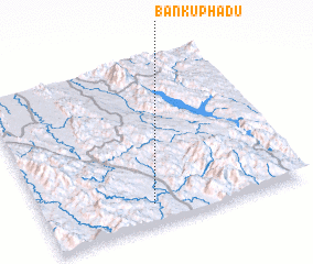 Places with similar names to Ban Ku Phadu, Thailand ::
// Ban Ko Pho (3) (TH)
// Bān Nokhvod (IR)
// Bena-Kafutu (CD)
// Bangoufida (NE)
// Ban Kava Tai (LA)
// Baniakafata (ML)
// Bangveti (GE)
// Bản Cò Fat (VN)
// Bankevid (SE)
// Bankfoot (GB)
Disclaimer :: Information on this page comes without warranty of any kind |
||
|
Where is Ban Ku Phadu? Elevation and coordinates ::
Latitude (lat): 15°7'0"N Longitude (lon): 98°25'0"E
Elevation (approx.): 266m (map arrows pan, magnifying glasses zoom) |
||
|
Visiting Ban Ku Phadu? Hotel/Accommodation ::
Book a hotel in Ban Ku Phadu Travel Guide ::
Buy a travel guide for Thailand rental cars ::
car rental offers GPS waypoint ::
download a GPX waypoint (PoI) of Ban Ku Phadu for your GPS receiver
|
||