|
search place name
|
||
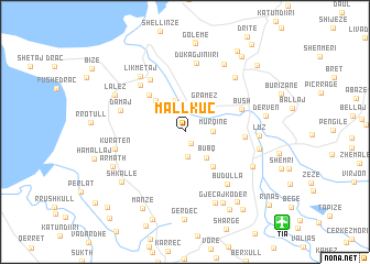
Mallkuç (Durrës, Albania)Mallkuç is a town in the Durrës region of Albania. An overview map of the region around Mallkuç is displayed below.
regional and 3d topo map of Mallkuç, Albania ::
Mallkuç airports ::
The nearest airport is TIA - Tirana Rinas, located 11.9 km south east of Mallkuç.
Other airports nearby include OHD - Ohrid (99.5 km east), TGD - Podgorica (100.7 km north), TIV - Tivat (125.7 km north west), DBV - Dubrovnik (163.4 km north west), Nearby towns ::
Mazha e Vogël (1.3km south) //
Mazha e Madhe (2.5km south) //
Murqinë (2.1km east) //
Sukth-Vendas (3.2km north) //
Gramëz (3.2km north east) //
Bubq (3.1km south east) //
Kullas (3.2km north west) //
Gjuricaj (3.8km north west) //
Ajaz (4.1km south east) //
Kapidanaj (4.7km north west) //
Bilaj (4.6km east) //
Bush (4.9km north east) //
Ishëm (5.9km north west) //
Kërtushaj (5.8km north west) //
Budulla (6.2km south east) //
Damaj (5.4km north west) //
Dukagjini i Ri (7.1km north) //
Likmetaj (6.6km north west) //
Kuratën (5.6km west) //
Thumanë (6.7km north east) //
Luz (5.7km east) //
Breg Shkozë (6.3km south east) //
Hasan (5.9km east) //
Palaq (7.6km south) //
Bushnesh (7.5km north east) //
Lalëz (6.5km north west) //
Armath (6.5km south west) //
(( Gjeçaj-Kodër )) (7.8km south) //
Kuçok (7.0km south west) //
[all distances 'as the bird flies' and approximate] 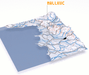 Places with similar names to Mallkuç, Albania ::
// Mialkougou (CM)
// Mèlako-auk (MM)
// Mǝlcǝk (AZ)
// Malaguikay (PH)
// Milokokkiá (GR)
// Melgaço (PT)
// Malakówka (PL)
// Mały Kack (PL)
// Miłkówko (PL)
// Mallkeq (AL)
Disclaimer :: Information on this page comes without warranty of any kind |
||
|
Where is Mallkuç? Elevation and coordinates ::
Latitude (lat): 41°29'53"N Longitude (lon): 19°37'54"E
Elevation (approx.): 15m (map arrows pan, magnifying glasses zoom) |
||
|
Visiting Mallkuç? Hotel/Accommodation ::
Book a hotel in Mallkuç Travel Guide ::
Buy a travel guide for Albania rental cars ::
car rental offers GPS waypoint ::
download a GPX waypoint (PoI) of Mallkuç for your GPS receiver
|
||