|
search place name
|
||
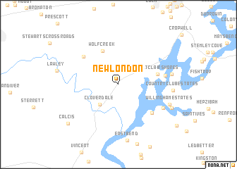
New London (Alabama, United States - USA)New London is a town in the Alabama region of United States - USA. An overview map of the region around New London is displayed below.
regional and 3d topo map of New London, United States - USA ::
New London airports ::
The nearest airport is BHM - Birmingham Intl, located 37.7 km west of New London.
Other airports nearby include ANB - Anniston Metro (48.0 km east), MXF - Montgomery Maxwell Afb (121.9 km south), HUA - Redstone Aaf (136.1 km north), MGE - Marietta Dobbins Arb (Atlanta Nas) (177.5 km east), Nearby towns ::
Cloverdale (4.0km south west) //
Wolf Creek (5.7km north) //
Saint Clair Shores (5.4km east) //
Cedar Cove Estates (6.4km south east) //
Pleasant Grove (6.4km north west) //
Logan Martin Pines (6.3km east) //
Alpine Bay (7.0km south east) //
Rocky Ridge (7.2km east) //
Willingham Estates (7.5km south east) //
Country Club Estates (7.3km east) //
Clear Creek Estates (8.0km south east) //
Calcis (9.1km south west) //
[all distances 'as the bird flies' and approximate]  Places with similar names to New London, United States - USA ::
// New London (US)
// New London (US)
// New London (US)
// Neu Lindenau (DE)
// New London (US)
// New London (US)
// New London (US)
// New London (US)
// New London (US)
// New London (US)
Disclaimer :: Information on this page comes without warranty of any kind |
||
|
Where is New London? Elevation and coordinates ::
Latitude (lat): 33°28'54"N Longitude (lon): 86°21'34"W
Elevation (approx.): 143m (map arrows pan, magnifying glasses zoom) |
||
|
Visiting New London? Hotel/Accommodation ::
Book a hotel in New London Travel Guide ::
rental cars ::
car rental offers GPS waypoint ::
download a GPX waypoint (PoI) of New London for your GPS receiver
|
||