|
search place name
|
||
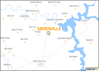
Gainesville (Kentucky, United States - USA)Gainesville is a town in the Kentucky region of United States - USA. An overview map of the region around Gainesville is displayed below.
regional and 3d topo map of Gainesville, United States - USA ::
Gainesville airports ::
The nearest airport is BNA - Nashville Intl, located 93.1 km south west of Gainesville.
Other airports nearby include FTK - Fort Knox Godman Aaf (118.4 km north), HOP - Hopkinsville Campbell Aaf (121.2 km west), LOU - Louisville Bowman Fld (159.0 km north), CHA - Chattanooga Lovell Fld (219.1 km south east), Nearby towns ::
Yesse (3.5km west) //
Meador (4.8km north) //
Port Oliver Ford (5.1km north) //
Cedar Springs (5.1km south east) //
Settle (5.4km north west) //
Finney (8.6km north east) //
Martinsville (9.6km north west) //
[all distances 'as the bird flies' and approximate] 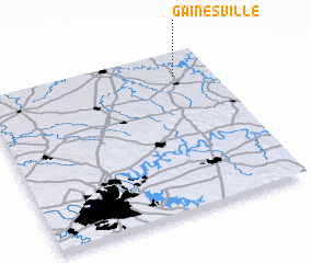 Places with similar names to Gainesville, United States - USA ::
// Gainesville (US)
// Gainesville (US)
// Gainesville (US)
// Kynesville (US)
// Gainesville (US)
// Keenesville (US)
// Queensville (US)
// Conesville (US)
// Gansville (US)
// Gainesville (US)
Disclaimer :: Information on this page comes without warranty of any kind |
||
|
Where is Gainesville? Elevation and coordinates ::
Latitude (lat): 36°51'2"N Longitude (lon): 86°9'30"W
Elevation (approx.): 164m (map arrows pan, magnifying glasses zoom) |
||
|
Visiting Gainesville? Hotel/Accommodation ::
Book a hotel in Gainesville Travel Guide ::
rental cars ::
car rental offers GPS waypoint ::
download a GPX waypoint (PoI) of Gainesville for your GPS receiver
|
||