|
search place name
|
||
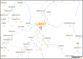
Lamut (Nueva Vizcaya, Philippines)Lamut is a town in the Nueva Vizcaya region of Philippines. An overview map of the region around Lamut is displayed below.
regional and 3d topo map of Lamut, Philippines ::
Lamut airports ::
The nearest airport is BAG - Baguio, located 51.5 km west of Lamut.
Other airports nearby include MNL - Manila Ninoy Aquino Intl (205.9 km south), Nearby towns ::
Junction (0.3km south west) //
San Miguel (1.5km south west) //
Bambang (1.8km north east) //
Ducait (2.0km west) //
Gadgadan (2.7km south) //
Almaguer (2.8km south west) //
Mauan (3.0km west) //
Balungao (3.6km north west) //
Domang (3.9km north) //
San Fernando (3.9km north east) //
San Antonio (4.1km south) //
Indiana (4.1km south west) //
Lamo (4.7km south) //
Barat (4.6km west) //
Guitao (4.8km north east) //
Camp Rosario (5.4km east) //
Ineangan (5.6km south) //
Makati (5.6km north east) //
Mabasa (5.8km south east) //
Barat (5.8km west) //
Santo Domingo (6.4km north) //
Gabut (6.5km south west) //
Inaban (6.6km south) //
Macasin (6.7km south east) //
Mangayan (6.8km south west) //
Malasin (7.0km south) //
San Felipe (7.3km north) //
Abian (7.5km north east) //
Nambebac (7.6km south) //
[all distances 'as the bird flies' and approximate]  Places with similar names to Lamut, Philippines ::
Disclaimer :: Information on this page comes without warranty of any kind |
||
|
Where is Lamut? Elevation and coordinates ::
Latitude (lat): 16°22'5"N Longitude (lon): 121°6'7"E
Elevation (approx.): 340m (map arrows pan, magnifying glasses zoom) |
||
|
Visiting Lamut? Hotel/Accommodation ::
Book a hotel in Lamut Travel Guide ::
Buy a travel guide for Philippines rental cars ::
car rental offers GPS waypoint ::
download a GPX waypoint (PoI) of Lamut for your GPS receiver
|
||