|
search place name
|
||
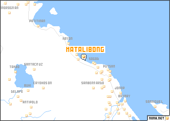
Matalibong (Albay, Philippines)Matalibong is a town in the Albay region of Philippines. An overview map of the region around Matalibong is displayed below.
regional and 3d topo map of Matalibong, Philippines ::
Matalibong airports ::
The nearest airport is KLO - Kalibo, located 242.3 km south west of Matalibong.
Nearby towns ::
Joroan (1.5km west) //
Nahologan (1.9km east) //
Sogod (2.2km east) //
Maynonong (2.2km north west) //
Naga (3.2km south east) //
Cale (3.6km south east) //
Misibis (3.8km north west) //
Libjo (4.3km south east) //
Cararayan (4.4km south east) //
Mayon (5.2km north west) //
Bolo (5.4km south east) //
Bagonbayan (5.6km south east) //
Bacolod (5.6km south east) //
Bagumbayan (5.6km south east) //
Putsan (5.9km south east) //
Bariis (5.9km south east) //
Dapdap (5.9km south east) //
Libtong (5.9km south east) //
San Bernardo (6.3km south) //
Tiwi (6.3km south east) //
Corocoro (6.8km south east) //
Gajo (6.9km south east) //
Nipa (6.9km south east) //
Nagas (7.0km south east) //
Malabog (7.1km south east) //
Borabod (9.0km south east) //
Tagoytoy (9.4km south east) //
Tabunturan (9.6km south east) //
Jonop (10.5km south east) //
[all distances 'as the bird flies' and approximate]  Places with similar names to Matalibong, Philippines ::
// Middle Bank (BZ)
// Matalbaniega (ES)
Disclaimer :: Information on this page comes without warranty of any kind |
||
|
Where is Matalibong? Elevation and coordinates ::
Latitude (lat): 13°29'17"N Longitude (lon): 123°38'0"E
Elevation (approx.): 6m (map arrows pan, magnifying glasses zoom) |
||
|
Visiting Matalibong? Hotel/Accommodation ::
Book a hotel in Matalibong Travel Guide ::
Buy a travel guide for Philippines rental cars ::
car rental offers GPS waypoint ::
download a GPX waypoint (PoI) of Matalibong for your GPS receiver
|
||