|
search place name
|
||
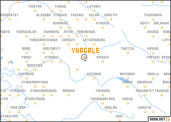
Ywagale (Myanmar)Ywagale is a town in Myanmar. An overview map of the region around Ywagale is displayed below.
regional and 3d topo map of Ywagale, Myanmar ::
Ywagale airports ::
The nearest airport is RGN - Yangon Intl, located 182.5 km south west of Ywagale.
Nearby towns ::
Bwetkale (1.9km north) //
Myaywa (1.9km north) //
Kyauko (1.9km north) //
Thanminyaung (2.6km south west) //
Myaunggyi (2.6km north east) //
Shanywa (2.6km north east) //
Yemyogan (2.6km north east) //
Sinwèki (3.5km east) //
Ketkako (4.1km south east) //
Letkandaung (4.1km north east) //
Zinga (4.1km north east) //
Gyutkon (4.1km north west) //
Komegyi (5.1km north west) //
Tabinbinwa (5.6km north) //
Gabalangweshazu (5.3km west) //
Tabinbinwa (5.8km north) //
Shanywayegu (6.6km north west) //
Nithè (6.6km north west) //
Pabèbo (7.0km west) //
Kyapoki (7.0km west) //
Mogyobyit (7.3km west) //
Bothet (7.7km north west) //
Takawdo (8.2km south east) //
Napoko (8.2km south west) //
Kyaukki (8.2km north east) //
Nithet (8.2km north west) //
Tithetki (8.2km north west) //
Kuhmaing (9.0km north west) //
Kuhmaing (9.1km north west) //
[all distances 'as the bird flies' and approximate] 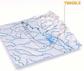 Places with similar names to Ywagale, Myanmar ::
Disclaimer :: Information on this page comes without warranty of any kind |
||
|
Where is Ywagale? Elevation and coordinates ::
Latitude (lat): 18°23'0"N Longitude (lon): 96°54'0"E
Elevation (approx.): 486m (map arrows pan, magnifying glasses zoom) |
||
|
Visiting Ywagale? Hotel/Accommodation ::
Book a hotel in Ywagale Travel Guide ::
Buy a travel guide for Myanmar rental cars ::
car rental offers GPS waypoint ::
download a GPX waypoint (PoI) of Ywagale for your GPS receiver
|
||