|
search place name
|
||
San Isidro (Bohol, Philippines)San Isidro is a town in the Bohol region of Philippines. An overview map of the region around San Isidro is displayed below.
regional and 3d topo map of San Isidro, Philippines ::

San Isidro airports ::
The nearest airport is NOP - Masbate Mactan Cebu Intl, located 81.1 km north west of San Isidro.
Other airports nearby include DGT - Dumaguete (126.5 km west), CGY - Ladag Cagayan De Oro (144.0 km south), TAC - Tacloban Daniel Z Romualdez (182.8 km north), BCD - Bacolod (191.3 km north west), Nearby towns ::
Kansuhay (0.7km south west) //
Mambool (0.8km east) //
Madua Sur (0.8km east) //
Madua (0.9km east) //
Mawe (1.4km north east) //
Canlangit (1.5km north west) //
Alijauan (1.7km south east) //
Duero (1.8km north east) //
Anibongan (2.1km north east) //
Naatang (2.4km south) //
San Antonio (2.6km north east) //
Lonoy (2.6km west) //
Cabungaan (2.8km south) //
Itum (2.9km north east) //
Cambugason (3.0km south west) //
Tubod Mar (3.2km south) //
Bantayan (3.3km north) //
Lanquis (3.3km north east) //
Bangwalog (3.5km north east) //
Duay (3.8km north) //
Abacjanan (3.8km west) //
Larapan (4.1km south) //
Lomboy (4.3km north west) //
Cantoyoc (4.5km south west) //
Naosoc (4.7km south) //
Pandan (4.9km south) //
Tejero (4.9km south west) //
Canjulao (5.0km south west) //
Mayana (5.1km north west) //
[all distances 'as the bird flies' and approximate] 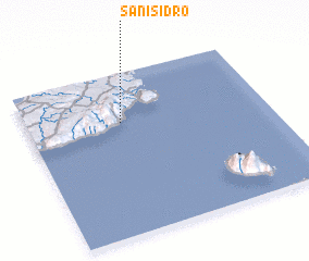 Places with similar names to San Isidro, Philippines ::
// San Ysidro (US)
// San Ysidro (US)
// San Isidro (PA)
// San Isidro (CU)
// San Isidro (CU)
// San Isidro (CU)
// San Isidro (CU)
// San Isidro (CU)
// San Isidro (ES)
// San Isidro (ES)
Disclaimer :: Information on this page comes without warranty of any kind |
||
|
Where is San Isidro? Elevation and coordinates ::
Latitude (lat): 9°41'56"N Longitude (lon): 124°23'33"E
Elevation (approx.): 9m (map arrows pan, magnifying glasses zoom) |
||
|
Visiting San Isidro? Hotel/Accommodation ::
Book a hotel in San Isidro Travel Guide ::
Buy a travel guide for Philippines rental cars ::
car rental offers GPS waypoint ::
download a GPX waypoint (PoI) of San Isidro for your GPS receiver
|
||