|
search place name
|
||
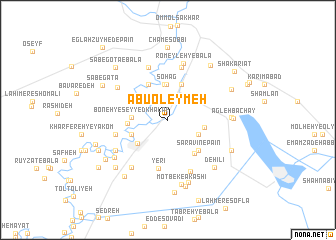
Abū ‘Oleymeh (Khūzestān, Iran)Abū ‘Oleymeh is a town in the Khūzestān region of Iran. An overview map of the region around Abū ‘Oleymeh is displayed below.
regional and 3d topo map of Abū ‘Oleymeh, Iran ::
Abū ‘Oleymeh airports ::
The nearest airport is MRX - Bandar Mahshahr Mahshahr, located 48.2 km south west of Abū ‘Oleymeh.
Other airports nearby include AWZ - Ahwaz (79.6 km north west), QMJ - Masjed Soleiman Shahid Asyaee (121.7 km north), ABD - Abadan (130.5 km south west), BSR - Basrah Intl (174.7 km west), Nearby towns ::
Abū Shenān-e Bālā (2.5km north east) //
Omm oţ Ţarfeh-ye Vosţá (2.5km north east) //
Ḩoseynīyeh-ye Sheneyen (2.8km north west) //
Ḩoseynīyeh-ye Kheẕayer (2.8km north west) //
Ḩoseynīyeh-ye Chāseb (2.9km north west) //
Hathida (3.3km south east) //
Ḩoseynīyeh-ye Fajer (4.0km north) //
Sohāg (4.0km north) //
Boneh-ye Seyyed Khalaf (3.5km west) //
Belād Moţlab-e Seyyed Fākher (3.5km west) //
Abū Shenān-e Pā'īn (3.6km east) //
Omm oţ Ţarfeh-ye Bālā (4.2km north) //
Rāmshīr (3.9km south west) //
Amīr ol Mo'menīn (3.8km south west) //
Abū Ţoveyj (3.9km west) //
Ḩoseynīyeh-ye Mashkūr (4.4km north west) //
Sarāvīn-e Bālā (4.5km south east) //
Sarāvīn-e Pā'īn (4.5km south east) //
Yerī (5.5km south) //
Seyyed Alwān (6.0km north) //
Romeyleh-ye Pā'īn (6.0km north) //
Belād Moţlab-e Seyyed Jāsem (5.3km west) //
Belād Moţlab-e Seyyed Yaḩyá (5.3km west) //
Cham-e Esḩāq (6.1km north) //
Qaryeh-ye Seyyed Maḩmūd (6.1km south) //
Romeyleh (6.5km north) //
Romeyleh-ye Bālā (6.5km north) //
Mesheylshīyeh-ye ‘Olyā (6.3km south west) //
Mesheylshīyeh-ye Pā'īn (6.3km south west) //
[all distances 'as the bird flies' and approximate]  Places with similar names to Abū ‘Oleymeh, Iran ::
// Āb Lamī (IR)
// Abalam (NG)
// Abalama (NG)
// Abulam (NG)
// Abuloma (NG)
// Abel Maueua (MZ)
// Abū ‘Alīmeh (IR)
// Ābīlamī (ET)
// Ablamé (TG)
// Aboloumé (BJ)
Disclaimer :: Information on this page comes without warranty of any kind |
||
|
Where is Abū ‘Oleymeh? Elevation and coordinates ::
Latitude (lat): 30°54'52"N Longitude (lon): 49°26'11"E
Elevation (approx.): 29m (map arrows pan, magnifying glasses zoom) |
||
|
Visiting Abū ‘Oleymeh? Hotel/Accommodation ::
Book a hotel in Abū ‘Oleymeh Travel Guide ::
Buy a travel guide for Iran rental cars ::
car rental offers GPS waypoint ::
download a GPX waypoint (PoI) of Abū ‘Oleymeh for your GPS receiver
|
||