|
search place name
|
||
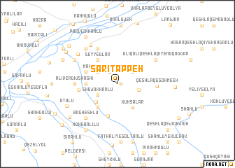
Sārī Tappeh (Iran)Sārī Tappeh is a town in Iran. An overview map of the region around Sārī Tappeh is displayed below.
regional and 3d topo map of Sārī Tappeh, Iran ::
Sārī Tappeh airports ::
The nearest airport is TBZ - Tabriz Intl, located 148.7 km south west of Sārī Tappeh.
Nearby towns ::
Ḩasan ‘Alī-ye Kadkhodālū (0.4km east) //
Shīrlū (2.2km north west) //
Kohl Jīk (2.7km north east) //
Shāh Valī (2.8km east) //
Shojā‘ Khānlū (3.0km south west) //
Ūsowblū (3.1km north west) //
Maḩmūd ‘Alīlū (3.1km north west) //
Tappeh-e Qeshlāq (3.9km south west) //
Kūhsālār (4.2km south east) //
‘Alī Khānlū (4.4km south west) //
Seyyedlar (4.5km north west) //
Sārī Beyglū (3.9km west) //
Qaţūrlār (5.2km south) //
‘Annāblū (4.4km north west) //
Sārī Beyglū-ye Kūchak (4.9km west) //
Qeshlāq-e Şowme‘eh (4.9km east) //
Kāsehlar-e Bālā (6.2km north west) //
Qarīyeh Qeshlāq-e Homāylū (6.2km north west) //
‘Alī Verdī Ūshāghī (5.3km west) //
‘Alī Qolī Qeshlāqī-ye Moqaddam (6.1km north east) //
Bāgheshlū (6.7km south west) //
Amīrāhlū (6.9km north west) //
Gūzī ‘Alī (6.9km north west) //
Moḩammad Şāleḩū (7.1km north west) //
Aḩmadlū-ye ‘Olyā (6.5km north west) //
Ḩasratān (6.9km north west) //
‘Aţālū (7.2km south west) //
Moḩeb ‘Alīlū (8.3km south west) //
Parvīz Khānlū (8.5km north west) //
[all distances 'as the bird flies' and approximate]  Places with similar names to Sārī Tappeh, Iran ::
// Surdup (BA)
// Sarıtepe (TR)
// Şārī Tappah (IQ)
// Sarytepa (UZ)
// Saurtepa (UZ)
// Zortepa (UZ)
// Sarydepe (TM)
// Sārī Tappeh (IR)
// Sar Tāp (IR)
// Sar Tāp (IR)
Disclaimer :: Information on this page comes without warranty of any kind |
||
|
Where is Sārī Tappeh? Elevation and coordinates ::
Latitude (lat): 39°13'57"N Longitude (lon): 47°12'43"E
Elevation (approx.): 385m (map arrows pan, magnifying glasses zoom) |
||
|
Visiting Sārī Tappeh? Hotel/Accommodation ::
Book a hotel in Sārī Tappeh Travel Guide ::
Buy a travel guide for Iran rental cars ::
car rental offers GPS waypoint ::
download a GPX waypoint (PoI) of Sārī Tappeh for your GPS receiver
|
||