|
search place name
|
||
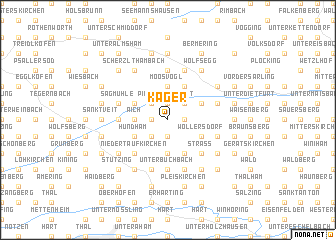
Kager (Bayern, Germany)Kager is a town in the Bayern region of Germany. An overview map of the region around Kager is displayed below.
regional and 3d topo map of Kager, Germany ::
Kager airports ::
The nearest airport is MUC - Munich Munchen, located 59.1 km west of Kager.
Other airports nearby include SZG - Salzburg (71.1 km south east), FEL - Fuerstenfeldbruck Furstenfeldbruck (99.3 km west), OBF - Oberpfaffenhofen (101.7 km west), LNZ - Linz (Horsching) (119.9 km east), Nearby towns ::
Albing (1.9km north) //
Fischeck (1.2km west) //
Leoprechting (1.2km east) //
Roßbach (1.9km south) //
Imming (2.2km north west) //
Grafing (2.2km north west) //
Piering (2.2km north west) //
Gottholbing (2.2km north east) //
Pirket (2.2km north east) //
Hellsberg (2.2km north east) //
Haunertsholzen (2.2km south west) //
Giglöd (2.2km south west) //
Moosvogl (3.7km north) //
Aich (2.5km west) //
Johannsbuchbach (3.7km south) //
Mitterbuchbach (3.7km south) //
Großthalham (3.1km north west) //
Hörbering (3.1km north west) //
Massing (3.9km north) //
Hundham (3.1km south west) //
Franking (3.1km south west) //
Anzenberg (3.1km north east) //
Froschau (3.1km north east) //
Moosbuch (3.1km south east) //
Breitendorf (3.1km south east) //
Nonnberg (3.1km south east) //
Wöllersdorf (3.1km south east) //
Höllthal (3.9km south) //
Arbing (4.5km south west) //
[all distances 'as the bird flies' and approximate]  Places with similar names to Kager, Germany ::
Disclaimer :: Information on this page comes without warranty of any kind |
||
|
Where is Kager? Elevation and coordinates ::
Latitude (lat): 48°22'0"N Longitude (lon): 12°35'0"E
Elevation (approx.): 465m (map arrows pan, magnifying glasses zoom) |
||
|
Visiting Kager? Hotel/Accommodation ::
Book a hotel in Kager Travel Guide ::
Buy a travel guide for Germany rental cars ::
car rental offers GPS waypoint ::
download a GPX waypoint (PoI) of Kager for your GPS receiver
|
||