|
search place name
|
||
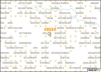
Kager (Bayern, Germany)Kager is a town in the Bayern region of Germany. An overview map of the region around Kager is displayed below.
regional and 3d topo map of Kager, Germany ::
Kager airports ::
The nearest airport is MUC - Munich Munchen, located 109.7 km south west of Kager.
Other airports nearby include LNZ - Linz (Horsching) (124.5 km south east), SZG - Salzburg (132.4 km south), KLV - Karlovy Vary (135.7 km north), BYU - Bayreuth (145.6 km north west), Nearby towns ::
Aign (0.0km north) //
Kogl (1.2km west) //
Weghof (1.2km west) //
Schreindorf (1.2km west) //
Wolfertsried (1.2km west) //
Randsburg (1.2km west) //
Au (1.2km west) //
Achslach (1.9km south) //
Hienhardt (1.9km south) //
Haidenberg (1.2km east) //
Lindenau (2.2km south west) //
Hochgart (2.2km south east) //
Tafertsried (2.2km south east) //
Schwarzen (2.4km east) //
Grün (3.9km south) //
Frath (3.9km south) //
Kalteck (3.9km south) //
Gotteszell (3.1km south east) //
Müllersdorf (3.9km north) //
Allersdorf (3.9km north) //
Maierhof (3.9km north) //
Liebhof (3.9km north) //
Einweging (3.9km north) //
Mooshof (3.1km north east) //
Tradweging (3.9km north) //
Weihmannsried (4.4km south east) //
Mühlen (4.4km south east) //
Weinhartsau (4.4km north west) //
Bramersberg (4.4km north west) //
[all distances 'as the bird flies' and approximate]  Places with similar names to Kager, Germany ::
Disclaimer :: Information on this page comes without warranty of any kind |
||
|
Where is Kager? Elevation and coordinates ::
Latitude (lat): 48°59'0"N Longitude (lon): 12°56'0"E
Elevation (approx.): 696m (map arrows pan, magnifying glasses zoom) |
||
|
Visiting Kager? Hotel/Accommodation ::
Book a hotel in Kager Travel Guide ::
Buy a travel guide for Germany rental cars ::
car rental offers GPS waypoint ::
download a GPX waypoint (PoI) of Kager for your GPS receiver
|
||