|
search place name
|
||
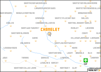
Chamelet (Rhône-Alpes, France)Chamelet is a town in the Rhône-Alpes region of France. An overview map of the region around Chamelet is displayed below.
regional and 3d topo map of Chamelet, France ::
Chamelet airports ::
The nearest airport is XVF - Vilefrance Tarare, located 12.9 km south east of Chamelet.
Other airports nearby include RNE - Roanne Renaison (40.8 km west), QNX - Macon Charnay (40.8 km north east), LYN - Lyon Bron (43.7 km south east), EBU - St.-etienne Boutheon (52.1 km south), Nearby towns ::
Létra (2.3km south east) //
Ternand (3.9km south) //
Chambost-Allières (3.9km north) //
Sainte-Paule (4.3km south east) //
Dième (4.3km south west) //
Saint-Laurent-dʼOingt (5.4km south east) //
Grandris (6.1km north west) //
Saint-Vérand (7.5km south) //
Saint-Just-dʼAvray (5.5km west) //
Saint-Cyr-le-Chatoux (6.8km north east) //
Oingt (6.3km south east) //
Saint-Clément-sur-Valsonne (7.6km south west) //
Le Bois-dʼOingt (9.0km south east) //
Légny (9.0km south east) //
Vaux-en-Beaujolais (9.0km north east) //
[all distances 'as the bird flies' and approximate]  Places with similar names to Chamelet, France ::
// Chemult (US)
// Chamalito (CO)
// Chimalito (MX)
// Shām Buldi (PK)
// Shāmilat (PK)
// Shāmilāt (PK)
// Shāmlāt (PK)
// Chumelito (HN)
// Shumba Alto (PE)
// Shumuultay (MN)
Disclaimer :: Information on this page comes without warranty of any kind |
||
|
Where is Chamelet? Elevation and coordinates ::
Latitude (lat): 45°59'0"N Longitude (lon): 4°31'0"E
Elevation (approx.): 453m (map arrows pan, magnifying glasses zoom) |
||
|
Visiting Chamelet? Hotel/Accommodation ::
Book a hotel in Chamelet Travel Guide ::
Buy a travel guide for France rental cars ::
car rental offers GPS waypoint ::
download a GPX waypoint (PoI) of Chamelet for your GPS receiver
|
||