|
search place name
|
||
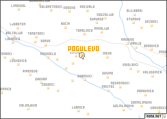
Pogulevo (Macedonia, The Republic of)Pogulevo is a town in Macedonia, The Republic of. An overview map of the region around Pogulevo is displayed below.
regional and 3d topo map of Pogulevo, Macedonia, The Republic of ::
Pogulevo airports ::
The nearest airport is SKP - Skopje, located 74.1 km north west of Pogulevo.
Other airports nearby include SKG - Thessaloniki Makedonia (130.6 km south east), OHD - Ohrid (144.6 km west), SOF - Sofia (147.9 km north east), KZI - Kozani Filippos (153.4 km south), Nearby towns ::
Damjan (1.4km north west) //
Gorna Vraštica (2.0km south west) //
Dolna Vraštica (3.6km south west) //
Gabrevci (4.6km south) //
Inevo (4.0km east) //
Dolni Radeš (5.2km south) //
Topolnica (5.7km north) //
Brest (4.4km west) //
Dedino (5.7km south east) //
Prnalija (6.8km north east) //
Novo Selo (6.0km west) //
Bučim (7.8km north west) //
Supurge (8.5km north) //
Rakitec (8.2km south east) //
Skoruša (8.2km south west) //
Šopur (7.1km north west) //
Zagorci (8.8km south west) //
Negrenovci (8.8km south east) //
[all distances 'as the bird flies' and approximate]  Places with similar names to Pogulevo, Macedonia, The Republic of ::
Disclaimer :: Information on this page comes without warranty of any kind |
||
|
Where is Pogulevo? Elevation and coordinates ::
Latitude (lat): 41°36'22"N Longitude (lon): 22°22'33"E
Elevation (approx.): 559m (map arrows pan, magnifying glasses zoom) |
||
|
Visiting Pogulevo? Hotel/Accommodation ::
Book a hotel in Pogulevo Travel Guide ::
rental cars ::
car rental offers GPS waypoint ::
download a GPX waypoint (PoI) of Pogulevo for your GPS receiver
|
||